Haupapa / Tasman Glacier (New Zealand)
The Human Imprint
For centuries, the frozen peaks of the Southern Alps stood as silent stone sentinels guarding the edge of the known world. Yet beneath their icy shrouds lies a living narrative: sacred Māori lore and daring alpine conquests have carved an indelible human imprint into the very breath of the glacier.
How did these massive, ice-draped peaks transform from celestial gods of ancient lore into the ultimate testing ground for human endurance and alpine science?
Do these two perspectives, the deeply spiritual ancestry of the Māori and the bold exploration of Western geographers, clash, or do they share a deeper connection?
The Inviolable Peaks
To Ngāi Tahu, the landscape is a living family tree. The peaks hold sacred "Tōpuni" status, securing legal recognition of their spiritual importance. Scaling the actual summit is viewed as a violation of these sacred boundaries, emphasizing a deep reverence for the mountain's natural water cycles.
The Vertical Proving Ground
For generations of mountaineers, this valley has been the ultimate testing ground. Here, early surveyors mapped massive, uncharted ice systems, and legendary climbers honed their vertical survival skills on crevasse-riddled ice cliffs.
For generations, the frozen giant seemed immoveable, anchoring the entire mountain range. Yet as global temperatures shifted, a silent, accelerating transformation was triggered deep within the valley. How drastically has this legendary river of ice retreated since we first began charting its borders?
The steady retreat of the main glacier over more than a century of monitoring, revealing a total loss of exactly 5.0 kilometers of ice as its warming terminus collapses into expanding proglacial waters.
Historical Length of the Tasman Glacier
- 1890: 28.5 kilometers
- 1920: 28.2 kilometers
- 1950: 28.0 kilometers
- 1980: 27.5 kilometers
- 2010: 24.5 kilometers
- 2026: 23.5 kilometers
Ball Glacier: The High Refuge
This prominent tributary glacier originates in a deep, bowl-shaped rock depression: a glacial cirque flanked by sharp, jagged ridges known as arêtes. Along its rugged moraine margins and stable stone slopes, rare rock wrens find crucial nesting refugia within boulder fields, sheltering from fierce alpine storms. Meanwhile, the inquisitive kea, the world's only alpine parrot, searches for food across the open, high-altitude slopes. The changing confluence where this ice stream meets the main valley floor has been a focus of scientific photographic monitoring since 1904, serving as a historic landmark along the classic route to the high pass.
The Alpine Outposts
While we map the ranges and write our histories, a far older struggle for survival plays out across the vertical boundaries of this landscape. From the valley floor to the nival summits, unique plants and resilient wildlife endure hurricane-force winds and volatile temperatures on bare stone.
How does life organize itself across the steep climatic zones of the valley, ascending from the proglacial lakebed to the frozen heights?
On the high glacier snowfields, a striking summer anomaly occurs. Mass blooms of specialized, microscopic single-celled algae (primarily Chlainomonas kolii and Chlamydomonas nivalis) stain the melting snow in pinkish-red streaks, producing a natural carotenoid pigment that acts as a biological shield against extreme ultraviolet radiation.
Is this specialized alpine ecosystem protected by its remote isolation, or does it face an unprecedented, multi-front threat from invasive species?
The Alpine Originals
The mischievous, olive-green kea acts as a dynamic geological force, tearing up alpine sod in search of grubs. Alongside it, the tiny, elusive rock wren survives entirely above the treeline, nesting inside deep cavities between unstable moraine boulders to shield its chicks from mountain storms.
The Introduced Threat
Introduced pests disrupt this delicate balance. Himalayan tahr and chamois graze high-altitude slopes bare, triggering severe erosion, while self-sown wilding pines creep up the valley floor, slowly overtaking native golden tussock grasslands.
Driven by climate warming, the temperature boundaries that divide these alpine zones are shifting upward. What trajectory does the permanent snowline (the altitude above which winter snow never melts) follow over decades of modern monitoring?
Climbing at a steady rate of nearly 3.7 meters annually, the rising snowline shrinks the available habitat for specialized alpine creatures, forcing them into a tight retreat toward the summits.
Upward Snowline Migration Trend
- 1980: 1,600 meters
- 1990: 1,637 meters
- 2000: 1,674 meters
- 2010: 1,711 meters
- 2020: 1,748 meters
- 2026: 1,770 meters
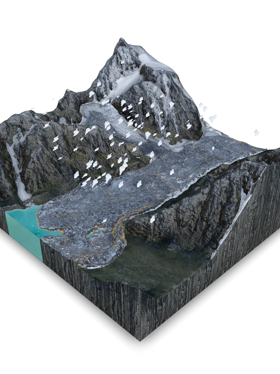
Haupapa: The Dark Leviathan
Carving a massive U-shaped valley, this grand river of ice is New Zealand's largest glacial reservoir. Viewed from above, this giant does not gleam with blinding white snow, but flows as a dramatic, dark-grey ribbon covered by a thick mantle of rock debris: dense sandstone and charcoal-black shale melting out onto the surface. Yet this harsh rocky expanse is remarkably alive, hosting vibrant mosaics of neon-yellow lichen on stable boulders that sustain rare native moths. Named in honor of Dutch explorer Abel Tasman and systematically mapped by surveyor T.N. Brodrick, this monumental glacier remains a globally renowned laboratory for geographic science and elite mountaineering.
The Crustal Clash
Beneath the fragile carpet of tussock and buttercups lies a colossal framework of raw planetary force. Deep within the crust, the collision of lithospheric plates and the grinding weight of temperate ice sculpt this alpine topography on a massive scale.
How did a massive, oblique-reverse backthrust fault system drive the vertical uplift and shape the structural corridor of this deep alpine pass?
As the peaks rise, the physical characteristics of the two primary rock types dictate how they weather. How do they compare?
Greywacke: The Unyielding Backbone
This dense, dark-grey sandstone (a rock so tough it matches the structural strength of industrial concrete) is packed with sharp, unweathered mineral grains. With a Mohs hardness of 6 to 7, it forms the rigid backbone of the mountain ridges, resisting erosion and fracturing under tectonic stress only into massive, angular blocks.
Argillite: The Shattering Shards
Interbedded with the tough sandstone is argillite, a soft, highly compressed clay mudstone that can be scratched with a pocket knife (hardness of 3 to 4). Highly fractured along delicate bedding planes, it shatters easily when water freezes in its crevices, turning solid cliffs into fine gravel that feeds active rockslides.
When did these monumental chapters unfold, and how long did it take to build the valley's solid stone foundation?
A chronological timeline showing how deep-sea sediments were compressed, folded, and thrust skyward to form the massive backbone of the Southern Alps.
Chronological Geological Epochs of Tasman Valley
- Rakaia Block (Deep-Sea Sand & Mud): 200 to 300 Million Years Ago
- Rangitata Epoch (First Great Squeeze): 160 to 200 Million Years Ago
- Pahau Addition (Stacking Newer Rock): 100 to 160 Million Years Ago
- Gondwana Split (Quiet Coastal Edge): 30 to 100 Million Years Ago
- Ocean Flooding & Mountain Uplift: 0 to 30 Million Years Ago
Tasman Lake: The Terminal Basin
Reaching depths of 240 meters, this proglacial lake formed in the late 1970s. Its milky-turquoise water is saturated with light-scattering rock flour ground from the bedrock. Along the braided, dynamic gravel shores near the outlet, the critically endangered black stilt (kakī) nests and hunts in the barren wetland. Symbolizing the Māori concept of 'Wai' (sacred water), the lake represents the physical transition of ancestral ice back into fluid, life-sustaining energy: binding deep geomorphology to spiritual rebirth.
Where Ice and Stone Converge
The towering rock walls of the Tasman Valley and the slow, heavy creep of Haupapa Glacier are far more than mere displays of tectonic uplift and physical erosion. They stand as a monument to the endless dialogue between planetary forces, the resilience of life, and the sacred stories of the human spirit. Here, the collision of lithospheric plates and the flight of the alpine parrot are not isolated events; they are threads in a single, indivisible lineage. Haupapa reminds us that even our planet's most colossal landmarks are dynamic, breathing, and profoundly vulnerable.
Quick Reference & Core Insights
What is the total loss of ice from the Tasman Glacier since monitoring began?
Historical monitoring records document a substantial and continuous reduction in the total length of the primary ice stream. Since systematic tracking began in 1890, the main glacier has experienced a total loss of exactly 5.0 kilometers of ice, shrinking down to 23.5 kilometers by 2026. This warming terminus continuously collapses into expanding proglacial waters. The long-term trend highlights how drastically this legendary river of ice retreats, altering the valley floor.
How was the Sawyer Stream power plant built in 1925?
Ground workers achieved a legendary feat of human endurance by deploying intensive manual labor to overcome severe sub-zero mountain environments. In 1925, construction teams dragged heavy metal pipes up a steep 45-degree slope entirely by hand. To allow the structural concrete to set properly in freezing cold, workers boiled water over campfires. This extreme physical effort completed the Sawyer Stream hydroelectric scheme, establishing a lasting alpine legacy.
Why is Tasman Lake water milky turquoise instead of clear?
The distinctive coloration of the proglacial basin is caused directly by suspended mineral particles generated through intensive bedrock grinding. Tasman Lake, which reached a maximum depth of 240 meters after forming in the late 1970s, is heavily saturated with light-scattering rock flour. This geological byproduct alters water clarity, transforming the terminal basin into a milky-turquoise ecosystem. The dynamic environment binds deep geomorphology to fluid, life-sustaining energy.
Mnemosyne Protocol
The 3D scan captures the shape, but misses the soul.
Upload your memory to preserve the feeling of this place.