Mount Tambora (Indonesia)
The Giant That Shook the World
A majestic peak reaching into the heavens was shattered in a single day of unbridled fury. The cataclysm did not merely bury thriving kingdoms under a shroud of ash: it rippled across oceans, freezing summers in Europe and North America, and proving that a volcanic heartbeat on one side of the globe could rewrite human history thousands of miles away.
To understand how a remote point on the Sanggar Peninsula became the epicenter of a global tragedy, we must trace the cascade of events that reduced a thriving civilization to ash. This timeline charts the path from historical hubris to geological retribution.
While folklore attributes the cataclysm to divine wrath, modern science unearths answers from the physical record preserved beneath the tephra. Are these oral histories mere parables, or do they mirror the terrifying reality of a vanished civilization?
DIVINE RETRIBUTION
To local descendants, the catastrophe remains a lesson in spiritual karma: an enduring warning of how mortal arrogance triggered the opening of the abyss, burying three kingdoms in folklore forever.
THE POMPEII OF THE EAST
In 2004, ground-penetrating radar revealed a tragic truth buried beneath three meters of ash. Archaeologists unearthed carbonized timbers, fine bronzes, and the skeletons of victims caught mid-motion, confirming a wealthy, sophisticated society frozen in time.
How did this massive collapse reshape the giant that once dominated the regional horizon?
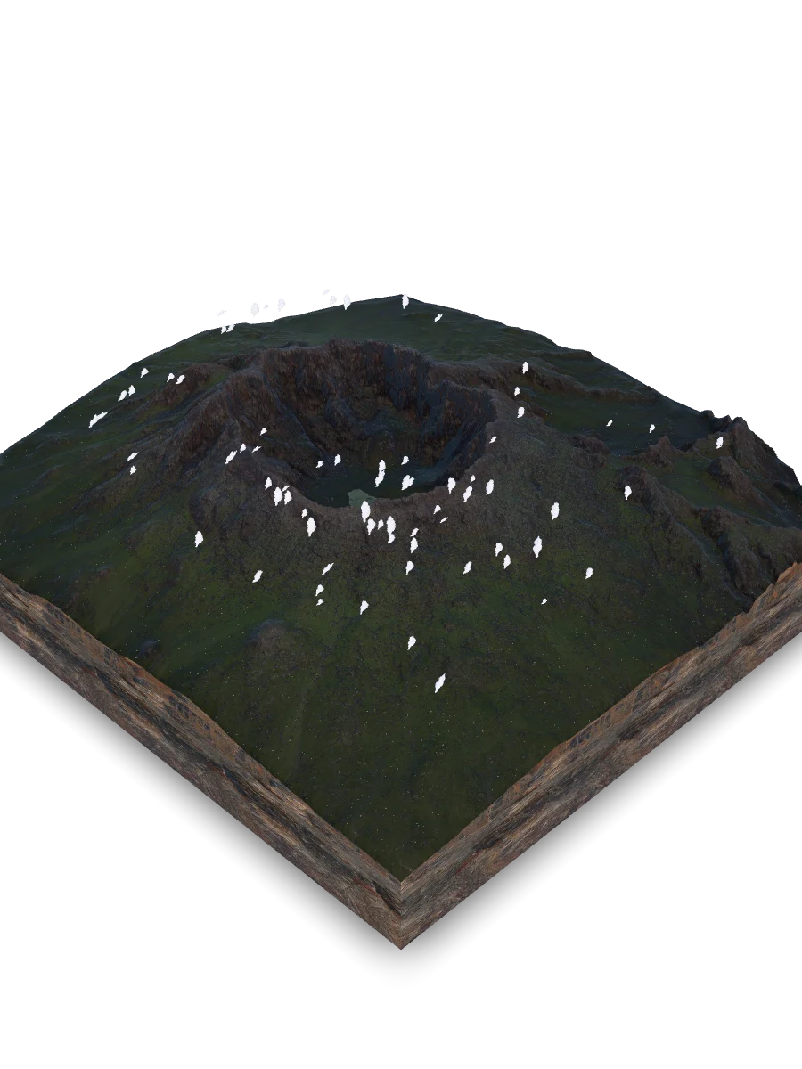
This chart illustrates the sudden loss of nearly a third of the mountain's elevation in April 1815. The towering summit, which once rivaled the tallest peaks of the Indonesian archipelago, was replaced by a vast, six-kilometer-wide caldera that has remained stable through two centuries of scientific monitoring.
Mount Tambora height change
- Before eruption: 4,300 m
- After eruption: 2,850 m
The Pompeii of the East
Carved by deep canyons and monsoon mudflows, the volcano's northwestern flank conceals a dark geological secret: a massive, 12-meter-thick blanket of Plinian pumice and welded ignimbrite. It was here, sealed beneath three meters of dry ash, that archaeologists discovered carbonized dwellings, fine bronzes, and the skeletal remains of a civilization frozen in its final moments, revealing the legendary Pompeii of the East.
The Emerald Staircase
While human kingdoms vanished in days, the quiet forces of nature immediately began reclaiming the scarred slopes. Today, Tambora stands as a living emerald staircase, with each altitudinal zone marking a distinct chapter of ecological resilience.
How does life ascend a slope choked by sterile ash and volcanic gasses? The ecological colonization of Tambora is a vertical saga of adaptation, with distinct pioneer species claiming territory at specific elevations to survive thin air and relentless monsoons.
This ecological rebirth is not a peaceful transition, but a fierce struggle between rapid grass invasions and the slow return of primary forests: a tension that shapes the volcano's modern slopes.
THE ALANG-ALANG GRASSLANDS
These vast, monocultural grasslands surged across the slopes after pyroclastic flows destroyed the native forests. While they stabilize loose ash and prevent erosion, their dense, matted root systems choke out germinating tree seeds.
NATURE’S ENGINEERS
Timor deer and long-tailed macaques act as ecological engineers. Migrating across elevations, they carve pathways through the dense grass and deposit the seeds of pioneer trees, slowly breaking the grassland monopoly and helping the forest climb back.
Yet, how does this harsh microclimate interact with changing elevations? And how do temperatures swing between the tropical coast and the subalpine rim across the changing monsoons?
This atmospheric profile reveals a steep thermal gradient: warm tropical lowlands give way to subalpine summit temperatures, shaping the intense wind patterns that sculpt the asymmetrical 'flag' crowns of Casuarina trees.
Altitudinal Temperature Gradient
- Base (377m) - Wet Monsoon: 28°C
- Base (377m) - Dry Monsoon: 26°C
- Summit (2850m) - Wet Monsoon: 9°C
- Summit (2850m) - Dry Monsoon: 8°C
The Howling Rim
Perched at a breathtaking altitude of 2,850 meters, the jagged basaltic ridges of the caldera rim act as a colossal acoustic instrument. When fierce monsoons strike, winds rushing through these stone teeth transform into a piercing, high-frequency howl. On these barren slopes, solitary Cemara gunung trees twist and warp under the raw power of the elements. These unforgiving cliffs stand as a solemn monument, guarding the timeless legend of a martyr whose spilled blood brought down a mountain giant.
The Magmatic Pipeline
Beneath the fragile forest floor and the transient nesting grounds of birds, a world of immense, crushing power shapes the deep Earth. This is the realm of plate collision, where the ocean floor plunges downward at several centimeters per year. This violent subduction zone melts the mantle wedge, feeding a complex, two-tiered magmatic plumbing system that remains one of the most volatile volcanic furnaces on our planet.
How does ocean water dragged into the mantle transform into a cataclysmic surface explosion? The pathway of Tambora's magma is a vertical pipeline of extreme heat and pressure.
The catastrophic collapse did not produce a uniform stone desert: instead, it exposed two highly contrasting geological zones of vastly different mechanical strength.
SOLID LAVA SHIELD
Massive trachyandesite (a potassium-rich, dark gray volcanic rock) possesses colossal compressive strength. These durable flows form the sheer vertical walls of the caldera, resisting erosion and fracturing only into massive blocks.
UNCONSOLIDATED ASH BLANKET
Unconsolidated pumice fall and loose ash horizons have virtually zero cohesion. Tropical downpours instantly wash them away, triggering destructive debris flows (lahars) that carve deep, flat channels completely devoid of soil or vegetation.
Can a planetary giant completely alter its internal architecture over hundreds of thousands of years? How many volcanic cycles did this mountain endure before its modern, shattered silhouette took its final form?
This timeline charts the evolutionary history of Mount Tambora, tracking its dramatic transformation from a gentle effusive shield to a towering, highly explosive stratovolcano.
Evolutionary epochs of Mount Tambora
- Effusive shield period (190,000 to 86,000 years ago): 104,000 years
- Explosive stratovolcanic period (86,000 to 4,000 years ago): 82,000 years
- Late Holocene pre- and post-caldera period (last 4,000 years): 4,000 years
The Ephemeral Mirror
At the flat floor of the colossal, 1,250-meter-deep caldera, an otherworldly sight takes shape. During the wet monsoon, an ephemeral freshwater lake forms, trapping a rare suspension of microscopic silica dust. While resilient Javanese edelweiss stubbornly claws its way up the sheer caldera scarps, local communities look down into this void with deep spiritual awe. For them, this silent chasm remains the sacred stage of divine retribution: the very spot where the spilled blood of Sa'id Idrus split a once-mighty peak apart.
The Ultimate Crucible
Tambora is ultimate proof of our interconnected world, showing how a single geological event can instantly rewrite global climate, disrupt nature, and alter the destiny of civilizations thousands of miles away.
Quick Reference & Core Insights
How did the 1815 eruption change the shape of Mount Tambora?
The catastrophic 1815 eruption radically altered the physical profile of Mount Tambora by shearing away its massive summit. Before the cataclysmic rupture, the mountain soared as a regional giant reaching an elevation of 4,300 meters. The sudden collapse vaporized nearly a third of its height, replacing the towering peak with a vast, six-kilometer-wide caldera that drops 1,250 meters deep. This dramatic structural failure permanently reset the local geography and established a stable, hollowed-out summit zone that remains monitored today.
Why are eruptions at Mount Tambora so violent and explosive?
The immense volatility of Mount Tambora stems from complex tectonic subduction processes. The Indo-Australian plate drives beneath the Sunda Plate at 6 to 7 centimeters annually, dragging ocean water 180 kilometers deep where intense pressure releases it into the hot mantle. This moisture lowers the mantle's melting point, creating a gas-rich alkaline melt that pools in a shallow chamber between 2.3 and 7.5 kilometers deep. This continuous accumulation of volatile gases builds the immense pressure required to trigger global climate-altering events.
Have archaeologists found proof of the civilizations destroyed by Tambora?
Modern scientific excavations successfully confirm the tragic reality of the vanished societies buried by the volcano. In 2004, researchers utilizing ground-penetrating radar beneath a three-meter-thick layer of dry ash uncovered the legendary Pompeii of the East. The physical team unearthed carbonized timbers, fine bronzes, and the skeletal remains of victims frozen mid-motion on the volcano's northwestern flank. These tangible discoveries validate the oral histories of a wealthy, sophisticated kingdom that was completely obliterated in less than seventy-two hours.
Mnemosyne Protocol
The 3D scan captures the shape, but misses the soul.
Upload your memory to preserve the feeling of this place.