Mount Shasta (Shasta-Trinity National Forest)
Two Worlds: A Sacred Mountain and a Lemurian Gate
To Native Americans, it is the sacred 'White Mountain' Úytaahkoo, a center of creation myths. To the modern world, it's a global magnet for those seeking Telos, a mystical city hidden within.
The mountain's introduction to the wider world was a gradual process, culminating in a legendary tale of survival.
Today, Mount Shasta exists in two parallel realities. It is a place where ancient mythology and modern legends collide.
Native Myth: Battle of the Spirits
For the Klamath tribe, the mountain is home to Skell, the spirit of the Upper World. His battle with Llao, spirit of the Lower World, by hurling red-hot rocks, is a mythic description of volcanic eruptions.
New Age Myth: Refuge of Lemuria
According to modern legends, a hidden underground city named Telos exists within the mountain. It is believed to be inhabited by advanced survivors from the mythical, sunken continent of Lemuria.
The mountain seems asleep, almost static. But if we look at the chronicle of events, is it really sleeping, or have we just gotten used to its rhythm?
Shasta never truly sleeps. The graph of debris flows shows that the mountain constantly "snaps back," reminding us of its wild nature every couple of years.
Data reflects the high-activity period of the 20th century. Frequency varies with climate cycles.
- 1900: 0
- 1920: 8
- 1940: 17
- 1960: 26
- 1985: 37
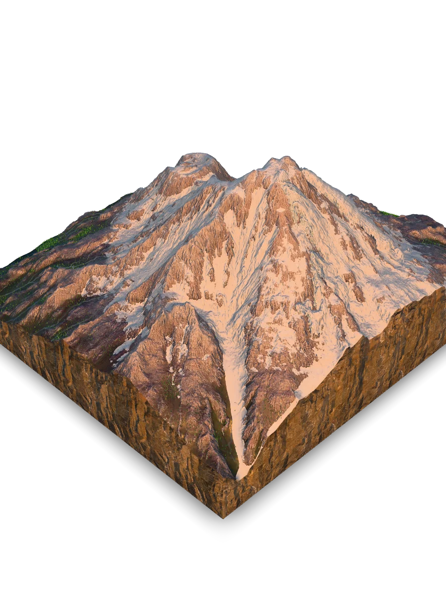
Shastina cone
The second-highest peak (3760 m) with a perfectly preserved crater, formed during a concentrated eruptive episode ~9,700 years ago, shortly before the ongoing growth of the modern Hotlum summit. On its slopes, volcanic ash created fertile soil, allowing the forest to rise to record heights. It acts as the "younger sister" of the giant, visually balancing its massive figure.
Vertical Worlds: From Forests to Ice
At such extreme elevations, life is not chaotic - it is strictly organized. The dramatic vertical relief of over 2,100 meters (7,000 ft) creates distinct "floors" of ecosystems on the mountain's slopes, each with its own rules and residents.
How does life adapt to this rapid ascent? It follows the climate, forming four distinct zones that one can witness while climbing from the base to the summit.
This vertical organization is only part of the story. The other key factor is which way the slopes "face." The mountain's orientation creates two completely different worlds on its eastern and western sides.
The Northeast Sector
This side receives significantly less sun and acts as a "trap" for wind-blown snow. As a result, it is cold and wet, allowing giant glaciers like Hotlum and Wintun to exist. It is the most biologically poor zone.
The Southwest Sector
This side "faces" the sun. It is warmer, drier, and has much less ice cover. These conditions have allowed subalpine ecosystems, especially Foxtail Pine forests, to become much better developed on the rocky slopes.
What is the primary driver of this stark difference? An extreme climatic gradient. The temperature difference between the sheltered base and the wind-swept summit is colossal.
A comparison of average July temperatures reveals the chasm: while the base (in the town of Mount Shasta) experiences summer highs of +29°C (84°F), the summit on the same day barely climbs above +6°C (42,8°F).
Extreme Temperature Gradient (Average July High)
- Base (Mt. Shasta Town, ~1100 m): 29°C
- Summit (at ~4322 m): ~6°C
Hotlum peak
The youngest and highest point of the complex (4322 m), formed by the extrusion of viscous lava. Lifeless cold reigns here, but it was the hot sulfur springs on this summit that once saved the life of naturalist John Muir. Today, this place is considered a dormant vent from which a new eruption could begin.
The Mountain Built Four Times
Mount Shasta is not a single mountain, but a colossal, still-active "compound" volcano. It was born from the slow dive of an oceanic tectonic plate beneath North America, a process that melts rock deep underground and feeds the entire Cascade Volcanic Arc.
How was this giant complex built? It wasn't a single act of creation, but rather four distinct "episodes" of construction, stacked on top of each other over hundreds of thousands of years. What we see today are merely the two youngest cones.
This building process continues, but today it faces two powerful, opposing forces. The mountain is simultaneously being built from within and carved from without. It is a contest between fire and ice.
The Force of Creation (Volcanism)
Deep beneath the mountain, magma is still active. At the summit of Hotlum Cone, this is visible as fumaroles hissing vents releasing steam and volcanic gases. The mountain is still "breathing" and capable of new eruptions, building itself up with thick, dacite lava.
The Force of Destruction (Erosion)
The mountain's slopes host massive glaciers, like Hotlum and Wintun. Meltwater from these glaciers mixes with loose volcanic rock, triggering frequent and powerful debris flows (lahars). These flows race downhill, carving deep canyons like scars into the volcano's flanks.
We see the mountain as it is now, but how long did nature build this "skyscraper"?
Mount Shasta is a young peak on an ancient foundation. The modern peak (Hotlum) is an infant compared to its older brother Sargent's.
Comparison of Cone Ages (years ago)
- Sargent's Ridge Cone: 250,000
- Misery Hill Cone: 130,000
- Shastina Cone: 9,800
- Hotlum Cone (Summit): 9,000
Hotlum & Wintun glaciers
These two massive ice fields are the mountain's active sculptors. Hotlum, the largest glacier, defied global trends by growing in the late 20th century, but facing rapid recession since 2020, while Wintun Glacier occupies the head of Ash Creek Canyon, a massive ravine sculpted by ancient Pleistocene ice and repeated debris flows. Together, they act as a paradox: they are vital freshwater reservoirs for the region, yet simultaneously serve as the primary triggers for destructive debris flows (lahars) that reshape the slopes below.
The Giant's Living Legacy
Mount Shasta is not just a geological point on the map of California. It is an arena where the eternal fire of the depths meets the eternal ice of the heavens, creating conditions for unique life and human legends. From the tiny pika hiding in the rocks to the climber storming the summit, everyone here finds their limit and their revelation.
Quick Reference & Core Insights
What is the temperature difference between Mount Shasta's base and summit in July?
An extreme climatic chasm divides the mountain's base from its peak, creating highly stratified environmental conditions. During July, the base town of Mount Shasta at approximately 1100 m experiences summer highs reaching +29°C. Conversely, on the exact same day, the wind-swept summit at 4322 m barely climbs above +6°C. This colossal thermal discrepancy forces life into strictly organized vertical ecosystem zones across a brief elevation rise.
How did John Muir survive the freezing summit blizzard on Mount Shasta in 1875?
Naturalist John Muir endured a life-threatening summit blizzard by utilizing the active thermal features of the volcano. Trapped during April 1875, Muir survived the night by huddling near the hot, acidic fumaroles of the Hotlum peak. This desperate action left him simultaneously frozen by the storm and scalded by the geothermal steam. Consequently, these volatile volcanic vents served as an ironic sanctuary, preserving human life amidst an otherwise fatal alpine environment.
Why are the Hotlum and Wintun glaciers considered dangerous?
The Hotlum and Wintun glaciers form a profound landscape paradox by acting as both vital resources and agents of destruction. While these massive ice fields serve as crucial freshwater reservoirs for the region, their meltwater frequently mixes with loose volcanic rock. This specific mixture triggers powerful debris flows, or lahars, that aggressively carve deep canyons into the volcano's flanks. This interaction ensures that the regional freshwater supply remains tied to the severe erosion of the volcano's flanks.
Mnemosyne Protocol
The 3D scan captures the shape, but misses the soul.
Upload your memory to preserve the feeling of this place.